Of Interest ·
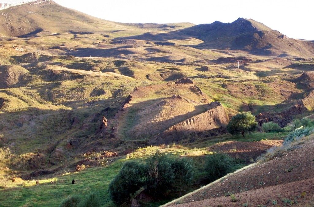
Burnt wood from ‘Noah’s Ark’ site near Ararat sent for carbon dating
A team is drilling and scanning the Durupınar formation in eastern Türkiye, long said by some to hold the remains of Noah’s Ark. Here is what the 2026 work reports, what geologists have said for decades, and what Genesis itself says about where the ark came to rest.
by VRSZ Editors · October 20, 2026 · 6 min read
A hill shaped like a ship
About 29 kilometers south of the summit of Mount Ararat, near the village of Üzengili outside Doğubayazıt, a long, pointed mound of earth rises from a sloping valley. Its walls stand out from the hillside, and from above it looks like the outline of a ship. Local accounts say heavy rain and earthquakes exposed it in 1948. In 1959 a Turkish army captain, İlhan Durupınar, noticed it in aerial survey photographs, and it has carried his name ever since.
Its length, about 157 meters by the current team’s count, is close to the 300 cubits of Genesis 6:15. A 1960 expedition dug and blasted into it and found only soil and rock. From 1977 the American explorer Ron Wyatt promoted it as the ark, and a visitor center was built on the bluff above it in 1987.
What the 2026 season reported
This year the most extensive investigation yet was carried out under Turkish government authorization. It is directed by Prof. Cenker Atila, an archaeologist at Sivas Cumhuriyet University, in cooperation with Noah’s Ark Scans, a U.S.-based group founded by Andrew Jones. Jones, an evangelical Christian who runs a tour company in Türkiye, says plainly that he believes the formation is the ark.
The team used ground-penetrating radar, electrical resistivity tomography and drone mapping, then drilled core holes. On October 1, Noah’s Ark Scans released a preliminary reading by Dr. Khosrow Bakhtar, the engineer behind the BakhtarRadar system, who said the imagery showed “organized” internal features, corridors and voids, and a structure that was man-made, not geological. None of this has been peer-reviewed.
The drilling reached about 18 meters. The team says it found soft, organic-rich sediment and no bedrock in the holes inside the formation. In one hole, at four to five meters, the drill bit broke on a hard layer. Jones told Newsweek that petrified or heavily mineralized wood is one possibility to test, and “a hard rock block within the surrounding debris is another.” He added: “When I said in our release that these layers could be the decayed top-tier remains of the Ark, I was describing the hypothesis we are testing, not a finding.”
Earlier soil work is part of the case. In 2024, 88 samples were taken from 22 locations inside and outside the formation under the geologist Salih Bayraktutan, with a survey designed by the Australian soil scientist Bill Crabtree. Analyzed at Atatürk University, the samples from inside showed about three times the organic matter (roughly 2.93 percent against 0.98), about 40 percent more potassium and lower pH. The team says this is what decayed wood would leave behind. A separate team from Istanbul Technical University, Ağrı İbrahim Çeçen University and Andrews University, working since 2021, reported clay and marine shell remains in its samples.
The newest step came on October 15, at the 8th International Ağrı Mountain and Noah’s Ark Symposium hosted by Ağrı İbrahim Çeçen University. Atila said that only about a fifth of the radar data had been processed. The team had again found corridor-like features, room-like voids and what he called a three-layered geological formation. It had also found a small amount of burnt wood, now at laboratories in Türkiye and France for species identification and carbon-14 dating. He expected the French results in about 15 days and the Turkish ones in about three months, and he did not say where in the formation the wood was found. Of the three layers he noted that the Bible gives the ark three decks, but he said the data cannot yet settle the question and the features may be geological. “As scientists, we must speak cautiously,” he said, as quoted by the İhlas News Agency.
The field team has packed up, and on October 16 @noahsarkscans posted that the soil and core samples had arrived at the lab. Fuller results are expected in 2027.
“As scientists, we must speak cautiously.”
Prof. Cenker Atila · project director, Oct 15, 2026, via İhlas News Agency (translated from the Turkish)
The skeptics’ case
The geological objection is decades old, and some of it comes from people who had hoped the site was the ark. In 1987 the geophysicist John Baumgardner, a creationist then at Los Alamos, and Bayraktutan surveyed the site with radar, magnetometers and seismic lines. The radar operator, Tom Fenner, said he could not reproduce the scans Wyatt had published. In 1988 they drilled four cores. Baumgardner concluded that the shape came from mud flowing around a narrow ridge of rock.
In 1992 the young-earth creationist geologist Andrew Snelling, writing in Creation magazine, drew on that work to call the site an “uplifted block and erosional remnant of basement rock.” He noted a bed of fossil-bearing limestone that runs across it. In 1996 the geologist Lorence Collins and David Fasold, once the site’s leading promoter, called it a “doubly plunging syncline,” a natural fold in the rock, in the Journal of Geoscience Education. They said the supposed iron fittings were weathered volcanic minerals and the “anchor stones” nearby were local rock. Fasold’s biographer, June Dawes, later wrote that he remained convinced it was the ark. Turkish geologists have since described the site as shaped by a landslide or earthflow: Murat Avcı in 2007, and Eşref Atabey of Türkiye’s mineral research directorate in 2025.
Critics today make a narrower point. “Finding straight lines and right-angles is not evidence of a man-made structure,” Rabbi Natan Slifkin of the Biblical Museum of Natural History wrote. Hard layers and organic-rich soil, he added, are not proof either. Jones himself has granted part of this: “Organic matter also accumulates naturally in soils and slope deposits, and even identifying ancient wood would not by itself establish human construction.”
Supporters answer that the geologists have never agreed among themselves, offering a fold, a sliding block and a ridge of bedrock. They also say the formation’s point faces uphill, and that this year’s holes inside the formation have not hit bedrock, though Baumgardner reported reaching it at about five meters in two of his.
Where the old samples came from
Supporters often say the skeptical geology rested on samples taken well away from the formation. The published record does not support that. Baumgardner wrote in 1988 that three of his four holes were “near the centerline of the site” and the fourth “near the outer flank,” and a site plan posted on the Noah’s Ark Scans website shows all four inside the outline. Collins never visited the site. He worked from twelve samples that Fasold collected “from various places along its length and width.” Snelling drew on the 1987–88 team’s data and on samples others had examined.
Distance does come into the record in two places. Baumgardner wrote that the rock layers in his cores matched those exposed in a roadcut “about a half mile” away, but that outcrop was used for comparison, not as the source of the samples. And the anchor stones that Collins tested stand at Kazan (Arzap), many kilometers away; they are a separate question. The supporters’ main complaints about the old work are different ones. Noah’s Ark Scans says the 1988 rig was the wrong kind, that water used to cool the bit washed material away, and that four 3.5-inch cores are far too few for a site this size. The new drilling is meant to answer exactly these complaints.
“The mountains of Ararat”
Genesis does not name a peak. “And the ark rested in the seventh month, on the seventeenth day of the month, upon the mountains of Ararat” (Genesis 8:4). The Hebrew hārê ʾărārāṭ is plural. Ararat is the biblical name for the land known in Assyrian records as Urartu, a kingdom around Lake Van. Elsewhere Scripture speaks of the “land of Ararat” (2 Kings 19:37, rendered “Armenia” in the King James Version) and the “kingdoms of Ararat” (Jeremiah 51:27). The high volcano now called Ararat took that name later.
Ancient writers placed the landing in different spots. Josephus says only that the ark “rested on the top of a certain mountain in Armenia,” which the Armenians called the Place of Descent. He quotes the Babylonian priest Berossus, who placed the ark’s remains “at the mountain of the Cordyaeans,” in Gordyene south of Lake Van. Aramaic and Syriac translations of Genesis render Ararat as Qardu, and the Qur’an names al-Judi, which an old tradition places at Cudi Dağı near Cizre. Durupınar, the summit of Ararat and Cudi each have their advocates.
Read it for yourself
Open VRSZ, tap Genesis 8:4, and read what the early Christian writers said about the ark coming to rest on the mountains of Ararat.
Genesis viii. 4
4And the ark rested in the seventh month, on the seventeenth day of the month, upon the mountains of Ararat.
Read the commentaries on Genesis 8:4Know someone who would want to read this?
Sources quoted
- İhlas Haber Ajansı, “Ağrı’da Nuh’un Gemisi araştırmasında radar çalışmalarının yüzde 20’si tamamlandı,” October 15, 2026 (Atila’s symposium remarks; quotations translated from the Turkish).
- Jordan King, “Noah’s Ark Hunters Build 3D Scale Model After Examining Site,” Newsweek, October 13, 2026; and “Noah’s Ark Hunters Testing for Wood After Drilling Mission,” Newsweek, 2026.
- Louis Keene, “Christian archaeologists are hell-bent on finding Noah’s Ark. Do they have a chance?” The Forward, October 14, 2026 (Slifkin quotation).
- Miriam Sela-Eitam, “Search for Noah’s Ark: Radar scan reveals claimed ‘man-made’ structure in Turkey,” The Jerusalem Post, October 3, 2026.
- Noah’s Ark Scans (@noahsarkscans) on X, October 1–19, 2026; press release, October 1, 2026; “Groundbreaking Soil Sample Results,” June 27, 2026; “Durupinar Core Drilling Locations and Results” (compiled Baumgardner statements, 1988–2021).
- John Baumgardner and M. Salih Bayraktutan, “July 1987 Geophysical Investigation of Noah’s Ark (Durupınar Site),” report to the Ağrı Province Noah’s Ark Commission, 1987.
- Andrew A. Snelling, “Special Report: Amazing ‘Ark’ Exposé,” Creation 14(4), September 1992.
- Lorence G. Collins and David F. Fasold, “Bogus ‘Noah’s Ark’ from Turkey Exposed as a Common Geologic Structure,” Journal of Geoscience Education 44(4), 1996, 439–444; Lorence G. Collins, “Noah’s Ark near Dogubayazit, Turkey?” Perspectives on Science and Christian Faith 68(4), 2016.
- Murat Avcı, “‘Noah’s Ark’: its relationship to the Telçeker earthflow, Mount Ararat, Eastern Turkey,” Bulletin of Engineering Geology and the Environment, 2007; Eşref Atabey, “Nuh’un Gemisi, heyelan etkisiyle oluşmuş jeolojik bir yapı,” 2025.
- Josephus, Antiquities of the Jews 1.3.5–6, trans. William Whiston.
- Genesis 8:4; 2 Kings 19:37; Jeremiah 51:27, King James Version.
- Header photo: the Durupınar formation, August 2007, by Mfikretyilmaz. CC BY 3.0, via Wikimedia Commons (cropped).